Paulo Alexandre Loução
«Y se vio la tierra entera, de repente, / Surgir redonda, del azul profundo.» Fernando Pessoa
Poema «Infante», en Mensagem
Después de que los Templarios fuesen hechos prisioneros el 13 de octubre de 1307, el rey portugués D. Dinis no aceptó la culpabilidad de los caballeros de Salomón e inició un largo proceso diplomático que permitió crear la Orden de los Caballeros de Nuestro Señor Jesucristo, tal y como consta en la bula papal Ad ea ex-quibus de Juan XXII. En general, todos los Templarios así como sus bienes fueron traspasados a esta nueva orden monástico-militar. Sólo el primer maestre de la Orden, Gil Martins, procedía de la Orden de Avis.
Un siglo después, el maestre de la Orden de Cristo deja de ser elegido en capítulo y pasa a ser nombrado por el rey. De este modo Enrique, hijo del rey D. Juan I, se convierte en gobernador de la Orden de Cristo con la autorización papal necesaria para tal efecto.
Portugal comienza su expansión marítima con la conquista de Ceuta en 1415 y a partir de 1420, el infante D. Enrique pasa gran parte de su tiempo en la antigua ciudad templaria de Tomar, sede de la Orden de Cristo, construyendo sus pazos y trabajando con su equipo en un proyecto que provocaría una revolución geopolítica e geográfica a nivel mundial.
El primer resultado de este proyecto fue la creación del arquetipo caballero-navegador. La nueva búsqueda del Grial se realizaría ahora por mar y el valor de los guerreros sería puesto a prueba por los elementos marinos. Simultáneamente, emerge una metodología de naturaleza científica que será la piedra angular del complejo sistema que permitió la realización de la obra. «Fue el alma la Ciencia y el cuerpo la Osadía», sintetizó genialmente Fernando Pessoa.
Pionerismo científico
«Craso error fue suponer hasta nuestros días que los descubrimientos y conquistas portuguesas no excedían un caso, todavía inaudito, de bravura colectiva. No fueron las lanzas, las corazas, las bombardas de las naves y la furia de moverlas, sino los regimientos, las cartas, los astrolabios, el método, la disciplina, en fin, la cultura y el espíritu organizador, los que triunfaron.»((
Jaime Cortesão, Influência dos Descobrimentos Portugueses na História da Civilização, INCM, Lisboa, 1993, p. 82)).
Jaime Cortesão
Hegel afirmo que «la llamada restauración de las ciencias, el florecimiento de las bellas artes y el descubrimiento de América y del camino a las Indias Orientales, son comparables a la aurora que tras largas tormentas anuncia de nuevo, por primera vez, un nuevo día. Este día es el día de la universalidad que irrumpe, por fin, después de la larga y pavorosa noche de la Edad Media (…).» Y el economista político Adam Smith, «El descubrimiento de América y del paso a las Indias Orientales pasando por el Cabo de Buena Esperanza, son los dos mayores y más importantes acontecimientos que recuerda la historia de la Humanidad.»
Sin embargo, lo que Hegel y Adam Smith no comprendieron (tal y como sucede en la mayoría de los centros culturales del planeta) es que tanto el Descubrimiento de América como el camino a las Indias Orientales fueron el resultado de un trabajo metódico, durante ocho décadas, realizado por los portugueses. Este trabajo fue iniciado por el infante D. Enrique y la Orden de Cristo en la segunda década del siglo XV, mucho antes de la llamada restauración de las ciencias protagonizada por Kepler, Copérnico, Giordano Bruno, Galileo, etc. En 1419 Zarco redescubre Madeira, en 1519 Fernando de Magallanes inicia el primer viaje de navegación alrededor del mundo y en un siglo, la total revolución geográfica.
El trabajo en I&D (investigación y desarrollo) de los portugueses fue dando frutos consecutivos.
Desde ya, la simplificación del cuadrante para medir la latitud a través de la estrella polar y la propia simplificación del astrolabio transformándolo en un astrolabio náutico. Con él era posible «pesar el sol» al medio día, o sea, reconocer la latitud en base al ángulo captado por el astrolabio y el apoyo de las tablas de declinación. Con la medeclina del astrolabio se leía la distancia cenital (el ángulo z), a esta se sumaba el valor de la declinación para ese día (el ángulo d); la latitud (j) es la suma de los dos: j=z+d.
El piloto iba apuntando todos los datos importantes de la navegación y, durante el regreso, los entregaba al cartógrafo para que los integrase en las «cartas de marear». Siempre que era necesario llamaban a especialistas internacionales como hizo el infante D. Enrique al recurrir a Jácome de Mayorca para la confección de los mapas.
La navegación astronómica, de día y de noche, fue una de las grandes contribuciones de los portugueses a la ciencia. Como afirmó Pedro Nunes, el matemático portugués que inventó el nonio, «es evidente que estos descubrimientos no se realizaron al acaso sino que nuestros navegadores partieron muy bien enseñados y previstos de instrumentos y reglas de astrología [astronomía] y geometría».
En la Ruta del Viaje de Vasco de Gama, atribuido a Alvaro Velho, se narra un pesaje del Sol.
Simultáneamente, fue necesario perfeccionar el concepto y construcción de los navíos. Así surgió la carabela portuguesa con velas latinas (triangulares), muy ágil y capacitada para bogar contra la corriente, se transformó en el barco ideal para las actividades de descubrimiento y prospección. Más tarde, cuando fueron necesarios navíos de mayor porte para la carrera a las Indias, se idearon la nau y el galeón.
La navegación en el Atlántico, cada vez más al sur, determinó una nueva ciencia náutica. Se detectaban nuevos regímenes de vientos y de corrientes marinas y de esta manera, los portugueses descubrieron la ruta de la vuelta de la Mina y, más adelante, la vuelta a lo largo en el Atlántico sur, absolutamente esencial para que los navíos de mayor porte pudiesen circunnavegar África. O sea, cuando llegaban a Cabo Verde ponían rumbo a occidente con el objetivo de contornar los vientos alisios y las corrientes marinas, invirtiendo el rumbo hacia oriente a la altura de Brasil. Este descubrimiento fue primordial para la creación de la Carrera de las Indias. Y Brasil, debidamente protegido por el rey portugués D. Juan II en el Tratado de Tordesillas, era fundamental para que los navíos hiciesen escala (aguada) y evitar el escorbuto.
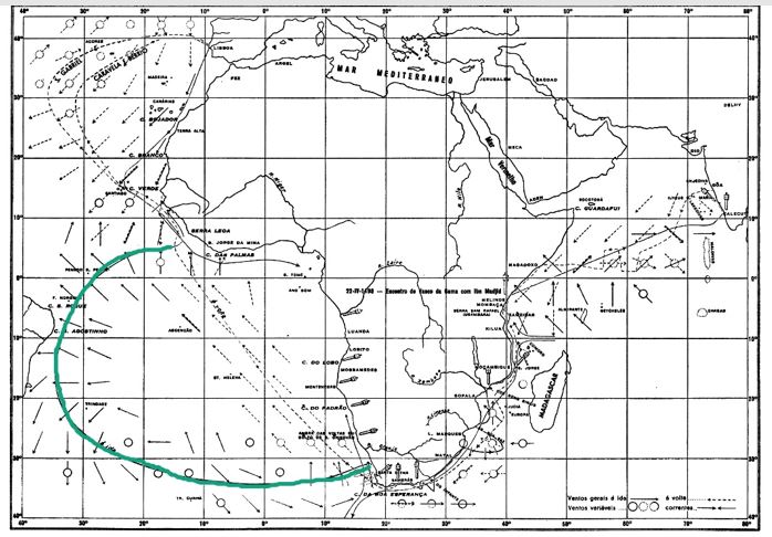 La Ruta del Viaje de Vasco de Gama la vuelta a lo largo en el Atlántico sur subrayada.
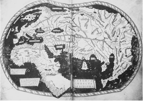
Uno de os grandes monumentos de los Descubrimientos Portugueses es el planisferio de Cantino. En 1502 el duque de Ferrara solicita a su espía en Lisboa, Alberto Cantino, que consiga un mapamundi elaborado por un cartógrafo portugués. Esto estaba completamente prohibido por la política del secreto(( A nuestro modo de ver, esta férrea política de secreto también se vio influenciada por el espíritu templario)). Pero Cantino consiguió corromper a un cartógrafo que confeccionó un mapa que es, hoy en día, uno de los mayores monumentos científicos de la epopeya lusitana. En él se puede observar una catalogación minuciosa y paciente, realizada en el siglo XV, de los más de diez mil kilómetros de la costa occidental africana. Ningún otro mapamundi anterior puede compararse con éste. Los mapas medievales no se ajustaban a la realidad, como afirma la historiadora francesa Geneviève Bouchon:
«El planisferio de Cantino, que hoy podemos admirar en la Biblioteca Estense de Módena, marca una ruptura con las tradiciones antiguas y medievales. Por primera vez se reconocen los límites del océano Índico. Tenemos sin duda que separar lo que fue la experiencia directa de las simples conjeturas. Muy nítida es la diferencia entre la corrección del dibujo de las costas realmente vistas y observadas por los portugueses y el esbozo imperfecto de las otras regiones, seguramente delineado a partir de mapas marítimos árabes. Si las costas septentrionales de Brasil aparecen desproporcionadas, las de África y la entrada al Mar Rojo están casi ajustadas a la realidad lo que se opone al leve trazado de un Asia apenas esbozada aunque ya en su lugar. El litoral de la India aparece recortado todavía de forma fantasiosa y la península de Malasia informe y desmesurada. Parece que este trazado del mundo había quedado en suspenso, preparado para ser perfeccionado cada vez que los portugueses obtenían nuevas certezas en sus diferentes avanzadas.»((Geneviève Bouchon, Afonso de Albuquerque – O Leão dos Mares da Ásia, Quetzal, Lisboa, 2000, pp. 30-31. Subrayado nuestro.)).
Hacia 1505 Duarte Pacheco Pereira escribió su magna obra Esmeraldo Situ Orbis. En ella establece como valor del grado terrestre el valor de 106,560 km, cuando el valor real es de 111 km; es decir, apenas un error del 4%. Una estimativa que sólo fue superada ¡en la segunda mitad del siglo XVIII!
La figura del infante D. Enrique
Gomes Eanes de Zurara en la Crónica de Guiné realiza el siguiente retrato de su señor, el infante D. Enrique:
«Sin embargo, vos quiero aquí escribir como todavía, por pungimiento de natural influencia, este honrado príncipe se inclina a estas cosas. Y esto porque su ascendente es Aries, que es la casa de Marte y la exaltación del Sol y su señor está en la XI casa, acompañado del Sol. Y porque Marte está en Acuario, que es la casa de Saturno, la casa de la esperanza, significa que este señor debe trabajar conquistas altas y fuertes, especialmente buscar las cosas que eran cubiertas a los otros hombres y secretas, según la cualidad de Saturno, en cuya casa él está. Y por estar acompañado del Sol, como dije, y el sol estar en casa de Júpiter, significa que todos sus tratos y conquistas son lealmente realizadas a placer de su Rey y señor.»
También registra en esta crónica los cinco objetivos principales, concretos, de la fase inicial de los Descubrimientos Portugueses, de cariz político, científico, cultural y religioso. Y finaliza con un sexto, raíz de los otros:
«Mas sobre estas cinco razones, tengo yo la VI, que parece que es la raíz de donde todas las otras proceden: o sea, inclinación de las ruedas celestiales que, como escribí no hace muchos días en una epístola que envié al señor Rey, ya que está escrito que el varón sabedor será señor de las estrellas, y que los cursos de los planetas, según la buena estimación de los Santos Doctores, no pueden impedir al buen hombre, es manifiesto sin embargo que son cuerpo s ordenados en el misterio de nuestro señor Dios, y corren por ciertas medidas y a desvariados fines, revelados a los hombres por su gracia, por cuyas influencias los cuerpos más bajos son inclinados a ciertas pasiones».
Un hecho importante en su liderazgo fue el paso del cabo Bojador por las barcas portuguesas.
En 1433 Gil Eanes intenta pasar el cabo Bojador pero no consigue ir más allá de las Canarias. Las supersticiones sobre el mar tenebroso y el miedo al océano eran una realidad medieval. El infante insiste con Gil Eanes, tenía que creer en el arte de navegar de los portugueses y no aceptar las supersticiones de la época. El navegador lusitano lo intenta al año siguiente y consigue pasar el cabo después de un trayecto de casi tres mil kilómetros. Las leyendas medievales se desvanecían y la ciencia náutica portuguesa ganaba peso.
Historiadores como Joaquín de Carvalho se preguntan ¿de dónde venía la convicción, la certeza del infante para convencer a sus hombres de tamaña aventura?
No tenemos respuesta pero sabiendo que la costa africana ya había sido recorrida en la Antigüedad, como quedó registrado en el periplo de Hanón, queda la sospecha de que tal vez en el siglo anterior los Templarios hubiesen traído a occidente mapas antiguos que sirvieron de brújula para los Descubrimientos Portugueses. No olvidemos también que los Templarios tenían una flota y leyendas sobre sus navegaciones a América.
Lo cierto es que un personaje como Ramón Llull aconsejaba en 1288, en el Çiber de Acquisitione Terræ Sanctæ, que los cristianos circunnavegasen África para llegar a la India, algo que los portugueses realizaron dos siglos después con la llegada de Vasco de Gama a Calcuta. Y en la cuestión 154 de las Quaestiones per artem demostrativam seu inventivam solubles, Llull escribió: «La tierra es esférica y el mar también es esférico(…). (…) Es necesaria una tierra opuesta a las playas inglesas; existe pues un continente que no conocemos.» Se plantea la misma cuestión. ¿Cómo es que Ramón Llull estaba seguro de que se podía circunnavegar África y que existía el continente americano?
La lógica nos lleva a plantear la hipótesis de que ciertos conocimientos de la Antigüedad hubieran llegado a las élites de la Europa medieval entre las que se encontraban los Templarios. Véase por ejemplo el fragmento del relato del marinero de la Antigüedad, Piteas de Marsella, en el que menciona cuatro observaciones de latitud, por tanto, ya existía el concepto de navegación astronómica.
Pensamiento sistémico en los Descubrimientos Portugueses
A nuestro ver, la realización de la epopeya lusitana como obra alquímica de un pueblo, fue posible gracias a un grupo de líderes que con base en la siempre presente tríada de valores valor-mística-ciencia, supo crear un pensamiento sistémico en base a cinco vectores:
1 – Ciencia
2 – Actividad comercial y análisis geoeconómica
3 – Diplomacia, estrategia Militar y poder bélico
4 – Encuentro de culturas y mestizaje
5 – Tradición mítica y espiritualidad
Si hubiese fallado uno de los cinco, la plasmación del proyecto no habría sido posible para un pueblo que contaba con una población de poco más de un millón de almas.
En el ámbito del poder militar citamos como ejemplo una innovación que fue crucial.
- Juan II(( Este rey D. Juan II, a quien Isabel la Católica llama «El Hombre», fue el líder de la segunda fase de los Descubrimientos Portugueses y fue quien condujo genialmente los procesos que, años después de su muerte, permitieron el descubrimiento del camino marítimo hacia la India y la oficialización del descubrimiento de Brasil. Cristóbal Colón, que aprendió el arte de navegar con los portugueses, estimaba mucho a este rey y cuando regresó de su primer viaje, en el que supuestamente había llegado a Asia, se encontró primero con D. Juan II en Portugal y luego continuó viaje hacia el sur de España.)), todavía príncipe, mandó abrir portañolas en los cascos de los navíos para que las bocas de fuego pudiesen ser montadas en la cubierta principal, próximas al nivel del agua. Esta importante innovación fue registrada por el cronista García de Resende: «[D. Juan II] ordenó que en pequeñas carabelas hubiesen muy grandes bombardas y que tirasen tan rasantes que casi iban tocando el agua; y él fue quien inventó esto (…)»((Crónica de D. João II, cap. CLXXXI.)).
Teniendo los portugueses la mejor artillería –ayudándose de la tecnología más avanzada de la época, del know-how de artesanos alemanes y realizando en Portugal las mejorías necesarias- con esta innovación tenían el arma secreta para dominar los mares, pudiendo así evitar en muchas ocasiones el abordaje y el inevitable combate cuerpo a cuerpo, que interesaba evitar debido a la constante inferioridad numérica de los portugueses.
Este pensamiento sistémico comenzó a decaer a finales del siglo XV y en el siglo XVI el país ya se sentía huérfano de círculos de liderazgo con inspiración templaria. La tierra surgió redonda del azul profundo pero quedó la sensación de que faltaba algo por cumplir. En el siglo XX, Fernando Pessoa escribía que faltaba descubrir las Indias espirituales, que están hechas de la misma materia que los sueños.